Elephant Hill, Aberdares
| Distance from Nairobi | About 90km |
| Starting Point | Njabini Forest Gate |
| Ending point | Njabini Forest Gate |
| Walking Duration | 7 hours |
| Terrain | Dirt road leading to swampy trail in the bamboo zone, before turning rocky in the alpine zone. |
| Difficulty | Moderate to High. You need to be reasonably fit to do this climb. |
Updated on 22nd January 2021
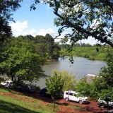
The Elephant Hill on the southern end of the Aberdares Ranges, about 90km north of Nairobi, is an ideal location for a day hike especially if you’re preparing for the more challenging Mt Kenya or Mt Kilimanjaro climbs. The Aberdares Ranges are situated west of Mt Kenya in the central highlands between Nyeri and Naivasha, and stretch 70km long from North to South. They are the water catchment area feeding two of the largest dams supplying over 95% of Nairobi’s water needs, i.e. Ndakaini Dam in the Thika region and Sasumua Dam near Njabini town. The Aberdares slopes are also one of the major bread baskets for vegetables supplied to Nairobi groceries, and possibly the most significant source of the second most important staple food consumed in Nairobi, the irish potato.
-

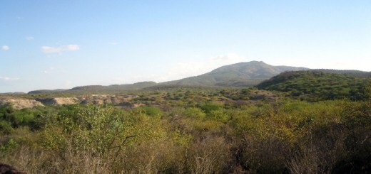
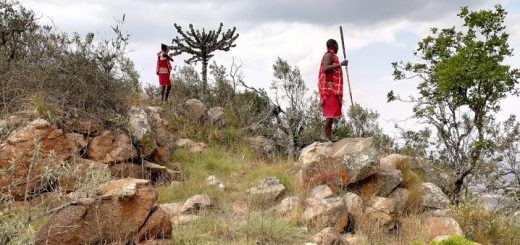
- Elephant Hill, Aberdares Range

-
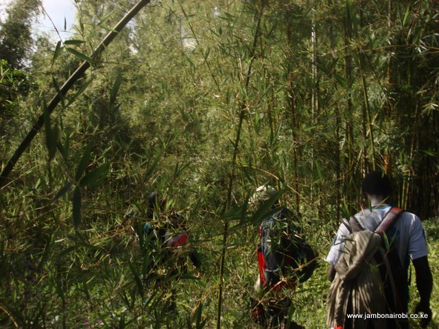
- Bamboo forest on Aberdares Range
-
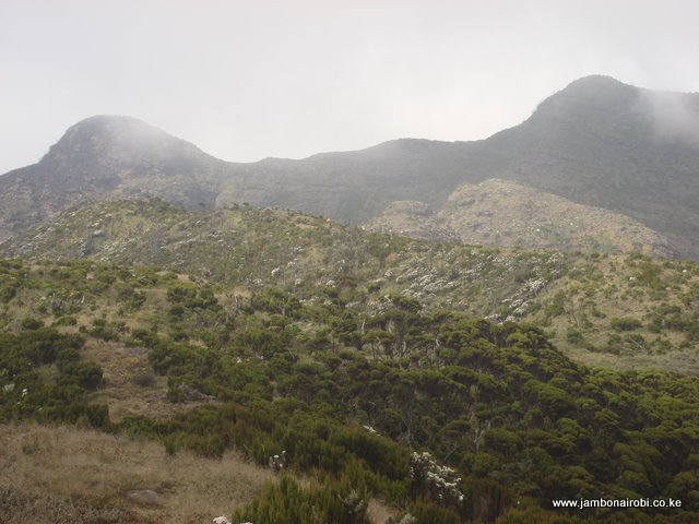
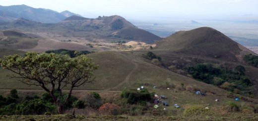
- View of the Summit
-
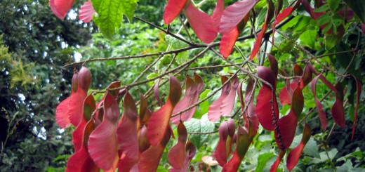
- Giant heather on the Aberdares Range

Route Description
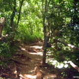
Although the hill can be ascended from various starting points, the best approach is the Njabini Forest Station (former Kinangop South Forest Station), about 4km from Njabini shopping centre. The hike up the hill takes 4 to 5 hours from an altitude of 2500m at the Forest Station. The first 5km kilometers are over relatively flat plantation forest covered terrain, with some controlled farming activity known as the Shamba system. The trail then turns sharply to the right and dives into the Bamboo zone. The narrow trail, punctuated every few steps by treacherous mud, at this point is covered by a canopy of towering bamboo with only filtered light getting through, as you continue trudging up the now steeper path. The occasional elephant footprint and droppings from various animal species are a constant reminder that you are in a game reserve teeming with wildlife, with the armed escort your only shield from possible danger.
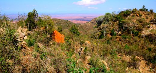
After what seems like hours of plodding though the muck and fighting the urge to throw in the towel and turn around, the trail finally levels off and the Bamboo thins out as you get to the alpine zone, characterized by the stunning array of outlandish flora like Giant Lobelia, Senecio, Tussock Grass, and Giant Heather among others; a real feast for botany enthusiasts. Amazing views of the surrounding countryside including the nearby Sasumua Dam down below to your right, and the distant Ndakaini Dam to your left, awaits those who make it this far. You are now at the elephant’s rump, also known as the point of despair.
For those strong enough to continue, the rest of the hike goes over slightly rocky terrain at an altitude of over 3400m above sea level, with the temperature dropping significantly, as you pick you way across the elephant’s back. The trail first descents into a clamp of trees before turning back upwards out of the small valley. It then gets pretty steep as it meanders past gnarled giant heather trees adorned with spanish moss offering handholds when you need to pull yourself up the slope. After what seems like another endless climb, the trail mercifully levels off to give you your first view of the summit. You’ll recognize it by the saddle between two knolls. Once you traverse the Elephant’s back to reach this saddle, you can reach either of the two summits in 5minutes. Most hikers prefer the 3625m high summit to the right, although the left one is higher at 3630m above sea level.The distinctive Kinangop peak, the second highest point on the Aberdares can be seen to the north.
The KWS rangers may try to discourage you from reaching the summit when you are within 15-20 minutes of getting there. They’ll give you reasons like the weather might change for the worse, or that its dangerously rocky. If your heart is set on getting there, feel free to politely insist on forging ahead, and avoid regretting later for turning back after getting so close.
The descent is just as trying as the ascent, taking a big toll on the knees, and another 3 to 4 hours to the Forest station.
Caution: Beware that the weather at this altitude can change for the worse very fast. Carry warm clothes and rain gear, and unless you are navigating by GPS, stop hiking if a fog moves in. Be prepared for the worst.
Guide
KWS rangers are not trained as guides. if you wish to meet your target, go with someone who knows the area well, or use GPS to navigate.
Getting There
If driving from Nairobi, take the new Nakuru Road on the upper escarpment for about 60km to a place known locally as flyover. Go over the flyover across Nakuru Road. A few meters after crossing, turn left at the next junction and drive about 24km to Njabini town. The Njabini Forest Station is 4km further on.
Entry Requirements
Although most visitors ask for KWS armed escort from Njabini Forest Gate, if you know the trail or have a guide, you can forego this service by signing an indemnity form. The official Kenya Wildlife Services (KWS) tariffs for Park entry and armed escort are applicable here. Call Cpl Wachira +254 725 655963, or the Senior Warden, Aberdare National Park +254 772 171 247, or send him an email on aberdaresw@kws.go.ke, to make arrangements for your visit.
Camping
Njabini Gate falls under Kenya Forestry Services (KFS). You will be expected to pay KFS rates if you wish to camp there.


Hello,
Thanks so much for the details about the Elephant Hill hike.
What I would love to know is if there are any other costs apart from the armed escort?
Thanks for asking Eugene. The only other costs are your transport from/to Nairobi, and for the lunch or snacks you bring along. The rangers don’t have a fixed cost, so be prepared to negotiate 🙂
Thanks for the reply JamboNairobi. Am heading there on April 17th, so I am definitely looking forward to it.
Thanks for all the information. We are thinking of heading from Nairobi to Njabini the night before. Do you know if anywhere in Njabini or around to stay?
Regarding a place to stay, I should add we’ll be making our way by public transport and there’ll be 2 or 3 of us.
Thanks again!
Thanks for asking Jenn. You’ll be able to get Lodging facilities at Njabini Market. If you prefer camping and have your own tent, you can pitch at the Park Gate. They have tap water and toilet facilities.
I would suggest you also call Julius (0725 408029), one of the Rangers at the Park Gate, to make advance arrangements for Park entry and armed escort. Nowadays they charge standard KWS rates at this place.
Enjoy the hike!
Thanks for your quick reply. Definitely worth calling ahead at this time of year – we’ve just been advised by the rangers not to even attempt to climb tomorrow because of recent rain.
I am planning to take a church youth group of about 70 guyz to the Abadares for a day trip. How ideal is the place for such a group, and are there any activities that can engage in, save for the hiking e.g an open field for games/ activities?
Thank you
I would like to hike there at the end of October. Kindly advise if this is a good time to hike or is it too wet and treacherous? It will be a day hike from Nairobi and back.
Thank you.
hello was asking how much does one pay as entry fee….n apart from charges with the armed escort are there any other charges
Click on the KWS Tariffs link provided above to get the entry fees. You’ll get all other details from the KWS website.
Thanks for this info, really helpful. We are a group of friends planning to go there this weekend, 15 nov 2014, and would like to invite anyone who would want to join in. please email se71411@gmail.com
I’m glad you found this useful. Good luck with your hike.
Hi there, We went up the Elephant yesterday (18.10.15). Entry fees for resident are 1,200/- pp & you have to take a guide at a cost of 3,500/-. We thought the charge for a guide was over the top.
On the way down we passed a group of over 20 with one guide. The group were spread out over 1km, make the use of a guide ineffectual. Furthermore the group were largely inappropriately dressed. one person was wearing flip flops and another sandals and none seemed to be having rain gear and few carried water. In addition litter was discarded on the walk. The KWS need to set some basic rules and regulations if this is to be maintained as a good experience. Furthermore, they should publish the rates on site – they were not.
Regards,
Andrew Gregory
Thanks for sharing your experience Andrew. KWS recently re-designed their website and forgot to restore the Tariffs page. I hope they are paying attention to this helpful feedback.
Hi, we were thinking about doing the same hike tomorrow (12 dec 2015) and were wondering what places there are to stay in the park at the foot of the hill or just outside the park?
thanks
Ernestine.
The KWS have a campsite at the Njabini Park Gate for those coming with their own tent, cooking gear etc. If you are thinking of a lodging, I’m not familiar with the facilities at Njabini town. It you call the KWS Sector Warden (listed above), he can advice you.
We had a hike on 9th July 2016 It was much awesome and we thank alot the support of this Game warden Called Mr Julius be blessed..
Does the trail allow for pets?
Does the trail allow for pets?
To my knowledge, pets are not allowed.
What are the requirements for a hike in elephant hill camp Aberdare
Answers are in the post. Kindly read it to the end.